Dunes

Cities have been designed from many different parameters throughout history. Ecobay takes a different approach. Located between the city and the nature we will create a new structure derived from programme, community and landscape.
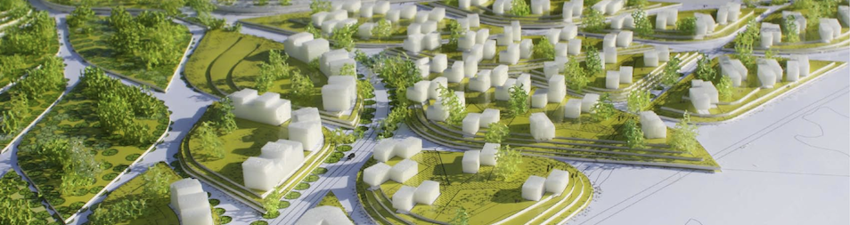
The Morphed grid is translated into a strong overall concept, where the grid becomes a binding system of dunes across the site. The concept effectively integrates the landscape and urban concepts for the three areas into a combined plan.
The dune concept subdivides each area into a number of decent sized dune islands. A dune can then assume different functions or design, according to its location and requirements. It can be flat, landscaped, planted, farmed, built, constructed as a building block, become a plaza or a parking lot, or even a lake. Thus the overall concept is very flexible.
When planning the stages, the dunes offer a strong and sustainable concept. The size and pattern of dunes allow a flexible development in time that can easily be adjusted. A single dune or a cluster of dunes can successfully function already before the final stages of the plan are completed.
The overall objective of modifying a dune is to reduce the visible impact of parking and internal dune infrastructure on the surrounding nature and public areas.


The specific landscape character in area A is envisioned as an extension of the wild bird sanctuary of the Natura 2000 area. It is ensured that the area will have an overall greenery percentage of 60 when the development is fully established. The area specific dune concept for area A ensures that dunes are built up as soft undulating hills rising from 1 to 6 metres above sea level. Possible conceptual dune designs are:
- Coastal landscape (low, sparse beach type soft landscape – pine, lyme grass, rose hip);
- Residential landscape (low and sparse Natura 2000 vegetation – birch, pine, populous tremuloides);
- Mitigation landscape (high, dense green wall – maple, oak, pine, chestnut).
The area specific dune concept for area B ensures that dunes are built up as hard urban landscape where the majority of dunes are constituted by building blocks. Towards the sea front basins form the dunes. To the East, dunes are formed by higher undulating hills, which constitute the mitigation between area B, and the WWTW. It is ensured that the area will have an overall greenery percentage of 25 when the development is fully established. Possible conceptual dune designs are:
- Mitigation landscape (high and dense green wall – maple, oak, pine, chestnut);
- Leisure landscape (high and dense towards WWTW, open and high stemmed towards urban area – sports areas, leisure and parking areas);
- Courtyard landscape (mainly hard surfaced landscape with elements of low green vegetation – sedum, grass, low bushes);
- Seas basins (bordered by concrete sea walls towards area B and permeable boulder breakwaters towards the sea);
- Pedestrian landscape.
The area specific dune conception for area C ensures that dunes are built up as a sculptured residential landscape. The two main topographic features of area C are the ponds bordering the sea front and the low park area in the middle of the area. It is ensured that the area will have an overall greenery percentage of 55 when the development is fully established. Possible conceptual dune designs are:
- Mitigation landscape (high, dense green wall – maple, oak, pine, chestnut);
- Residential landscape (sculpted landscape – open and high stemmed trees and low dense bushes ensure a free view in between the two);
- Park landscape (soft park landscape with sculpted landscape elements integrating sports and leisure activities – birch, pine, populous tremuloides);
- Coastal landscape (low, sparse beach type soft landscape – low willow, grasses, rose hip).